Robbing NISAR to pay ISRO
A.K. Anil Kumar, the director of ISRO's Telemetry, Tracking, and Command Network (a.k.a. ISTRAC), has reportedly made some seriously misleading comments as part of his convocation address at a Maharishi University in Lucknow.* Kumar's speech begins at the 1:38:10 mark in this video (hat-tip to Pradx):
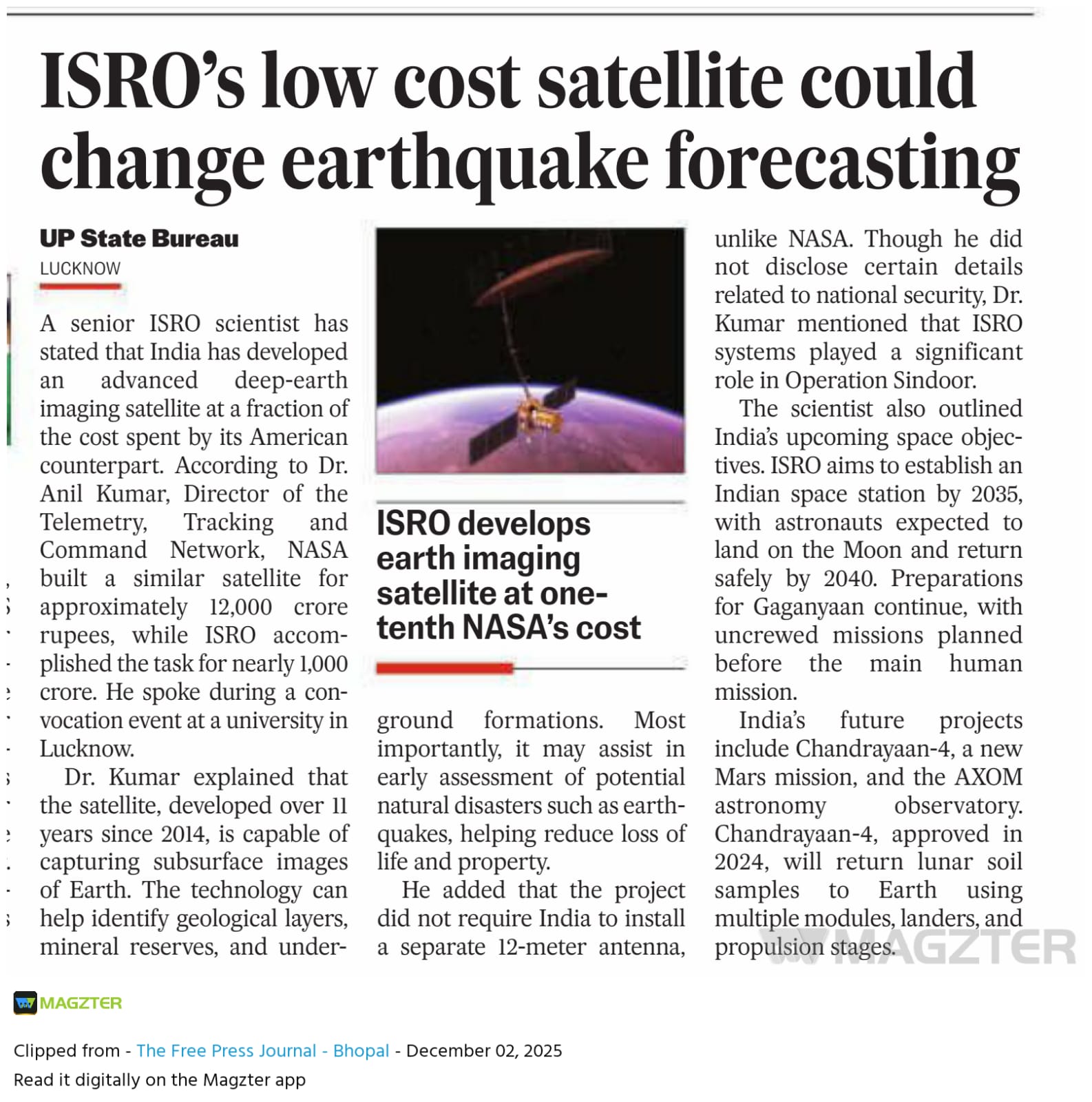
A poorly written article in The Free Press Journal (which I couldn't find online) has amplified Kumar's claims without understanding that the two satellites Kumar was seemingly talking about are actually one: the NASA-ISRO Synthetic Aperture Radar (NISAR), developed jointly by the US and Indian space agencies. The article carries an image of NISAR but doesn't caption it as such.
The article makes several dubious claims:
- That the "satellite" can forecast earthquakes,
- That NISAR can capture subsurface images of Earth, including of underground formations,
- That India's "satellite" didn't require a 12-metre-long antenna the way NASA's "satellite" did, and
- That ISRO's "satellite" was built at one-tenth of the cost of NASA's "satellite"
To be clear, an ISRO satellite that can forecast earthquakes or image subsurface features and which the organisation built and launched for Rs 1,000 crore does not exist. What actually exists is NISAR, a part of which ISRO built. The claims are almost spiteful because they purport to come from a senior ISRO official whose work likely benefited from the ISRO-NASA collaboration and because he ought to have known better than to mislead.
NISAR is a dual-frequency (DF) synthetic aperture radar (SAR). The 'DF' bit means the satellite captures data on two radar frequencies, L-band and S-band. To quote from a piece I wrote for The Hindu on July 27:
At the time the two space organisations agreed to build NISAR, NASA and ISRO decided each body would contribute equivalent‑scale hardware, expertise, and funding. … [ISRO] supplied the I‑3K spacecraft bus, the platform that houses the controls to handle command and data, propulsion, and attitude, plus 4 kW of solar power. The same package also included the entire S‑band radar electronics, a high‑rate Ka‑band telecom subsystem, and a gimballed high‑gain antenna.
'SAR' refers to a remote-sensing technique in which a small antenna moves along a path while using a computer to combine the data it captures along the way, thus mimicking a much larger antenna. NISAR uses a 12-metre mesh antenna plus a reflector for this purpose. Both the S-band and L-band radars use it to perform their functions. As a result of using the SAR technique, the two radars onboard NISAR are able to produce high-resolution images of Earth's surface irrespective of daylight or cloud cover and support studies of ground deformation, ice sheets, forests, and the oceans.
In this regard, for The Free Press Journal to claim NISAR "didn't require India to install a separate 12-metre antenna, unlike NASA" gives the impression that ISRO's S-band radar didn't need the antenna. This is wrong: it does need the antenna. That NASA was the agency to build and deploy it on NISAR comes down to the terms of the collaboration agreement, which specified that ISRO would provide the spacecraft bus, the S-band radar (and its attendant components), and the launch vehicle while NASA would take care of everything else. This is the same reason why ISRO's contributions to NISAR amounted to around Rs 980 crore — which Kumar rounded up to Rs 1,000 crore — whereas NASA's cost was around Rs 10,000 crore.
The antenna is in fact an engineering marvel. Without it ISRO's S-band radar wouldn't be so performant and thus its data wouldn't be so useful for decision-making for both research and disaster management. On the day ISRO launched NISAR, on July 30 this year, I got to interview Karen St. Germain, the director of the Earth Science Division at the Science Mission Directorate at NASA. Here's an excerpt from the interview about the antenna:
Both the L-band and the S-band radars use the same reflector. Since S-band has a shorter wavelength than the L-band, does this create any trade-offs in either L-band or S-band performance?
It doesn’t. And the reason for that is because this is a synthetic aperture radar. It creates its spatial resolution as it moves along. Each radar is taking snapshots as it moves along. You know, to get this kind of centimetre level fidelity and the kind of spatial resolution we’re achieving, if you were to use a solid antenna, it would have to be five miles long. Just like when you’re talking about a camera, if you want to be able to get high fidelity, you need a big lens. Same idea. But we can’t deploy an antenna that big. So what we do is we build up image after image after image to get that resolution. And because of this technique, it’s actually independent of wavelength. It works the same for S- and for L-bands. The only thing that’s a little different is because the antenna feeds for the L-band and the S-band can’t physically occupy the same space, they have to be next to each other and that means there’s a slight difference in the way their pulses reflect off the antenna. There’s that positioning difference, and that we can correct for.
Could you tell us a little bit more about that slight difference?
Karen St. Germain: It’s the way a reflector works. You would ideally want to put the feed at the focal point of the reflector. But when you have two feeds, you can’t do that. So they’re slightly offset. That means they illuminate the reflector just slightly differently. The alignment is just a little bit different. The team optimised the design to minimise that difference and to make it so that they could correct it in post-processing.
And even for all these abilities, we (i.e. people everywhere) currently don't know enough to be able to forecast earthquakes. What we can do today is make short-term predictions and we can prepare probabilistic forecasts over a longer period of time. That is, for instance, we can say "there's a 20% chance of a quake of magnitude 8 or more occurring in the Himalaya in the next century" and we have the means to alert people in an area tens of seconds before an earthquake occurs. We can't say "there will be an earthquake in Chennai at 3 pm tomorrow".
The question for The Free Press Journal is thus what role a satellite can essay in this landscape. In a statement in 2021, ISRO had said "NISAR would provide a means of disentangling highly spatial and temporally complex processes ranging from ecosystem disturbances to ice sheet collapses and natural hazards including earthquakes, tsunamis, volcanoes and landslides." This means NISAR will help scientists better piece together the intricate processes implicated in earthquakes — processes that are distributed over some area and happen over some time. Neither NISAR nor the S-band radar alone can forecast earthquakes.
On a related note, the L-band (1,000-2,000 MHz) and S-band (2,000-4,000 MHz) radar frequencies do overlap with the frequencies used in ground-penetrating radar (10-4,000 MHz). However, the lower the frequency, the further underground an electromagnetic wave can penetrate (while keeping the resolution fixed). Scientists have documented a ceiling of around 100 MHz for deep geological profiling, which is far from either of NISAR's radars. Even the L-band radar, which has lower frequency than the S-band, can at best penetrate a few metres underground if the surface is extremely dry, like in a desert, or if the surroundings are made of water ice. What both radars can penetrate very well is cloud cover, heavy rain, and vegetation.
The ISRO + NASA collaboration that built NISAR was a wonderful thing that the agencies need to replicate in future even as it continued their less formalised engagements from before and whose benefits both host countries, India and the USA, continue to accrue in the satellite observation and remote-sensing domains. For Kumar to call the cost component into question in the way that he did, followed by the The Free Press Journal's shoddy coverage of his remarks, does no favours to the prospect of space literacy in the country.
* I updated this post at 7.45 pm on December 2, 2025, to make it clear that all but one of the objectionable claims were made by The Free Press Journal in its article; the exception was the cost comparison, which Kumar did make.